In response to a nationwide and local driver shortage, the Bethlehem Central School District is proposing changes to bus transportation eligibility to reduce the number of bus routes, beginning next school year. These changes could impact up to 700 students districtwide beginning in 2022-23. The proposed changes shown on the maps below would need to be approved by a public vote in May before they could be implemented for the new school year.
If approved, the district expects it could eliminate 4-5 bus routes, reducing the number of drivers needed by 4-5 and helping to stabilize student transportation across the district. If the measure is not approved, a similar number of routes would still need to be consolidated, resulting in longer bus rides and more students on each bus.
The district is seeking feedback on these proposals before March 16, when the Board of Education would decide on whether to include a change to transportation eligibility on the ballot in May. You can email your feedback, questions or concerns to districtoffice@bethlehemschools.org. All comments will be shared with district administrators and members of the Board of Education. If you are unable to access the map below, please call the BCSD Communications Office at 518-439-3650.
Slingerlands Elementary: Proposed Walk Zone
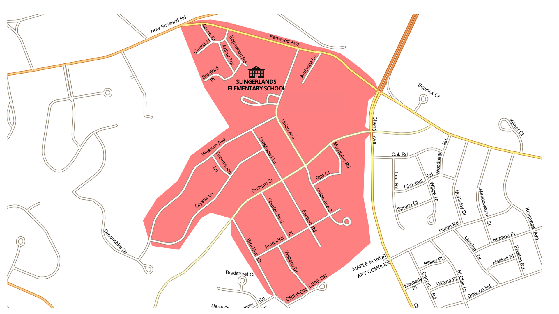
- If a family’s home is within the large shaded area on this map, the student would not be eligible for district transportation as part of the proposed change. The family would be responsible for getting their child to/from school.
- Only households within the large shaded areas are included in the expanded walk zone.
- Share your feedback, questions or concerns via email at districtoffice@bethlehemschools.org
List of Streets within Proposed Slingerlands Walk Zone
- Adriance Ln – All
- Arthur Ter – All
- Bradford Pl – All
- Brockley Dr – Both sides from Orchard St to Summit Rd
- Carroll Pl – All
- Charles Blvd – All
- Crestwood Ln – All
- Crystal Ln – All
- Edgewood Rd – All
- Elwood Rd – All
- Frederick Pl – All
- Greenwood Ln – All
- Grove St – All
- Kenwood Ave – Both sides from New Scotland Ave to Cherry Ave
- Magdalen Rd – All
- Orchard St – Both sides from Brockley Dr to Cherry Ave
- Rita Ct – All
- Summit Rd – All
- Union Ave – All
- Union Ave S – All
- Wallace Dr – All
- Western Ave – Both sides from Crystal Ln to Union Ave