In response to a nationwide and local driver shortage, the Bethlehem Central School District is proposing changes to bus transportation eligibility to reduce the number of bus routes, beginning next school year. These changes could impact up to 700 students districtwide beginning in 2022-23. The proposed changes shown on the maps below
would need to be approved by a public vote in May before they could be implemented for the new school year.
If approved, the district expects it could eliminate 4-5 bus routes, reducing the number of drivers needed by 4-5 and helping to stabilize student transportation across the district. If the measure is not approved, a similar number of routes would still need to be consolidated, resulting in longer bus rides and more students on each bus.
The district is seeking feedback on these proposals before March 16, when the Board of Education would decide on whether to include a change to transportation eligibility on the ballot in May. You can email your feedback, questions or concerns to districtoffice@bethlehemschools.org. All comments will be shared with district administrators and members of the Board of Education. If you are unable to access the map below, please call the BCSD Communications Office at 518-439-3650.
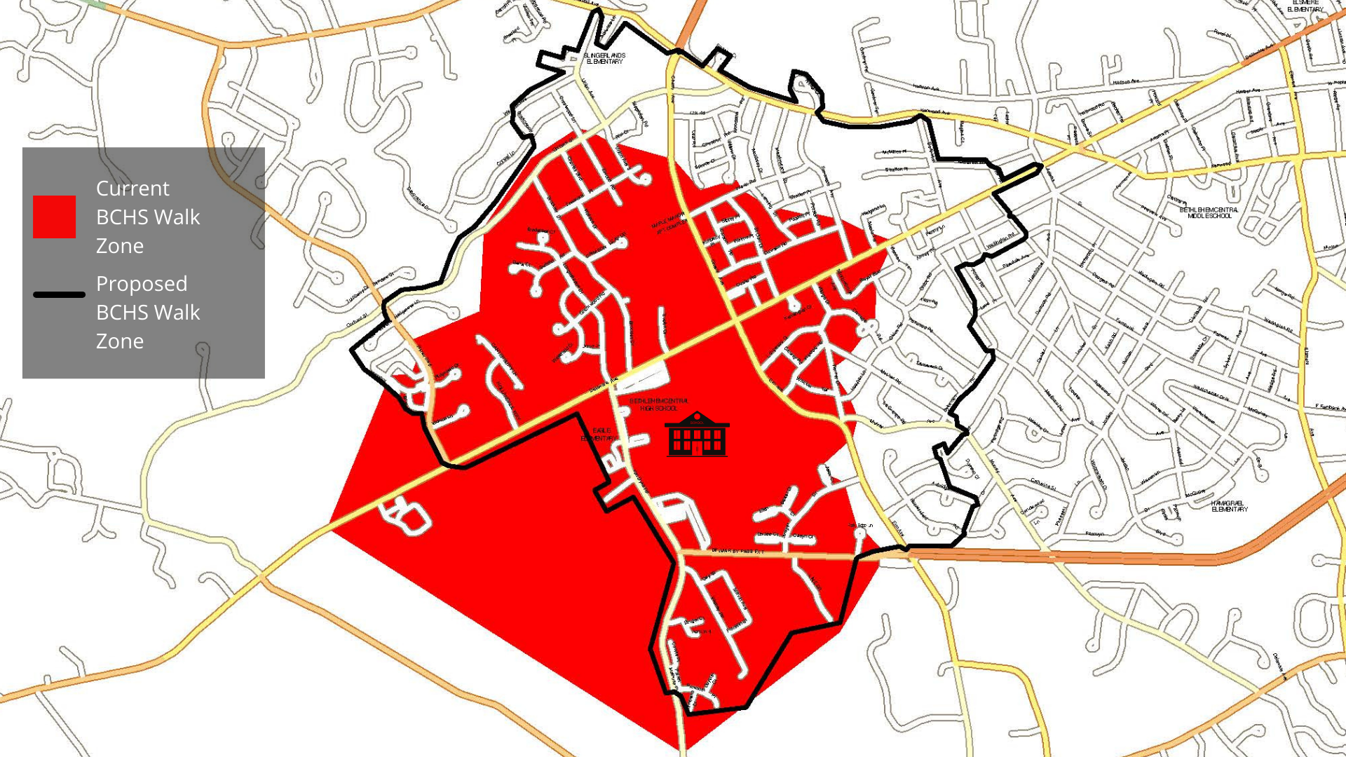
BCHS: Proposed Walk Zone
- If a family’s home is within the large shaded area on this map, the student would not be eligible for district transportation as part of the proposed change. The family would be responsible for getting their child to/from school.
- Only households within the large shaded areas are included in the expanded walk zone.
- The black outline is the current BCHS walk zone.
- Share your feedback, questions or concerns via email at districtoffice@bethlehemschools.org
List of Streets within Proposed BCHS Walk Zone
- Abbey Rd – All
- Adams Pl – Both sides from Marlboro Rd to Winne Rd
- Aertsan Pl – All
- Astor Ct – All
- Avon Rd – All
- Axbridge Ln – All
- Baxter Ct – All
- Bennett Ter – All
- Borthwick Ave – All
- Bradstreet Ct – All
- Brockley Dr – All
- Brugel Ct – All
- Canterbury Ln – All
- Carriage Rd – All
- Carson Rd – All
- Catlyn Ct – All
- Charles Blvd – All
- Cherry Ave – Both sides from Kenwood Ave to Delaware Ave
- Chestnut Rd – All
- Coorte Pl – All
- Crestwood Ln – All
- Crimson Leaf Dr All
- Crystal Ln – Both sides from Union Ave to Greenwood Ln
- Custer Rd – All
- Dana Ct – All
- Darroch Rd – Both sides from Huntersfield Rd to Darroch Rd (1st entrance)@ Durham Ct
- Dawson Rd – All
- Delaware Ave – Both sides from Fisher Blvd to Adams St
- Delmar Bypass Ext – Both sides from Van Dyke Rd to Park Edge Ln
- Derzee Ct – All
- Dorset St – All
- Duyster Ct – All
- Dyer Ter – All
- Dykeman Rd – All
- Elkin Ct – All
- Elm Ave – Both sides from Delaware Ave to Delmar Byp
- Elwood Rd – All
- Equinox Ct – All
- Evelyn Dr – All
- Fisher Blvd – Both sides from Orchard St to Delaware Ave
- Forest Rd – Both sides from Adams Pl to Wellington Rd
- Fox Hollow Greene – All
- Franklin St – All
- Frederick Pl – All
- Galway Rd – All
- Gay St – All
- Grantwood Rd – All
- Greenwood Ln – All
- Haskell Pl – All
- Heather Ln – All
- Hedgerose Ln – All
- Hollandale Way – All
- Huntersfield Rd – Both sides from Woodmont Dr to cul-de-sac
- Huron Rd – All
- Juniper Dr – All
- Kenaware Ave – All
- Kensington Ct – All
- Kenwood Ave – Both sides from Cherry Ave to Kilmer Ct
- Kilmer Ct – All
- Kimberly Pl – All
- La Grange Rd – All
- Lansing Dr – All
- Leaf Rd – All
- Line Dr – All
- Longmeadow Dr – All
- Longwood Dr – All
- Magdalen Rd – All
- Mansion Blvd – All
- Maple Ter – All
- Marlboro Rd – Both sides from Adams Pl to Lake Pl
- Marvin Ave – All
- McKinley Dr – All
- McMillen Pl – All
- Meadowland St – All
- Minnowbrook Ave – All
- Mosher Rd – All
- Murray Ave – Both sides from Elm Ave to Darroch Rd
- Nathaniel Blvd – Both sides from Borthwick Ave to Dyer Ter
- Oak Rd – All
- Oldox Rd – All
- Orchard St – Both sides from Fisher Blvd to Kenwood Ave
- Park Edge Ln – All
- Parker Mathusa Pl – All
- Paxwood Rd – All
- Penny Ln – All
- Preston Rd – All
- Provoost Pl – All
- Rembiano Ct – All
- Ridgefield Dr – All
- Rita Ct – All
- Roweland Ave – Both sides from Delaware Ave to Wellington Rd
- Royal Blvd – All
- Sibley Pl – All
- Spruce Ct – All
- St Clair Dr – All
- Stratton Pl – All
- Summit Rd – All
- Tamarack Dr – All
- Tierney Dr – All
- Union Ave – All
- Union Ave S – All
- Vadney Rd – All
- Van Dyke Rd – Both sides from Delaware Ave to Provoost Pl
- Victoria Ln – All
- Village Dr – All
- Wakefield Ct – All
- Wallace Dr – All
- Wayne Pl – All
- Weigand Ln – All
- Wellington Rd – Both sides from Forest Rd to Winne Rd
- Western Ave – Both sides from Union Ave to Greenwood Ln
- Wexford Rd – All
- Wicklow Ter – All
- Willow Dr – All
- Winne Rd – Both sides from Delaware Ave to Wellington Rd
- Woodbine Rd – Both
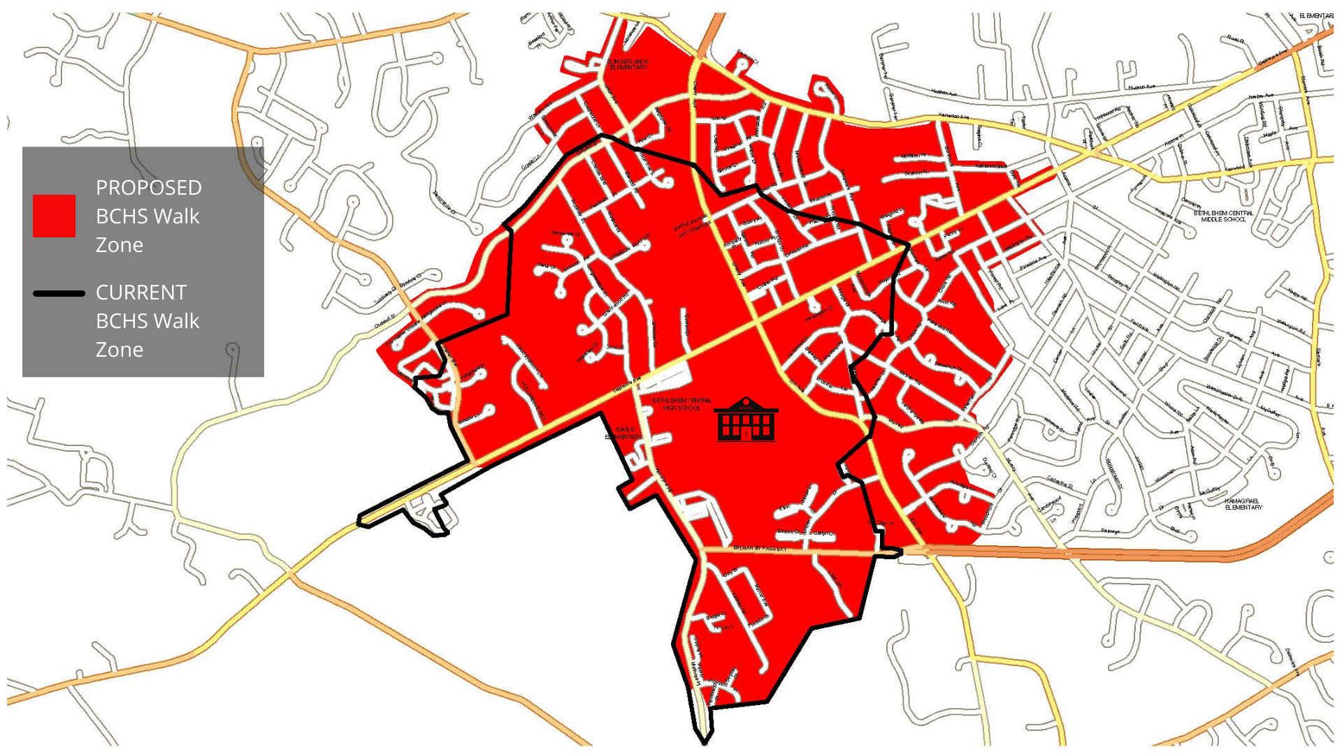
BCHS: Current Walk Zone 2021-22 vs. Proposed Walk Zone 2022-23